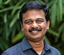
Kiran Mathramkot Chandrasekharan

Senior Consultant – Geospatial Lab | kchandrasekharan at iihs dot ac dot in

EDUCATION:

2013    MSc, Geography University of Madras Chennai, Tamil Nadu, India
1993    BSc, Mathematics Sree Narayana College, University of Calicut Alathur, Kerala, India


Countries: India, Sri Lanka, Myanmar, Laos, Ethiopia, Tanzania
States: Karnataka, Tamil Nadu, Kerala, Maharashtra
Cities: Bengaluru, Colombo
Languages: English, Malayalam

Kiran Mathramkot Chandrasekharan is a geospatial analyst who focuses on the applications of geospatial technologies in various aspects of land, water, and ecosystem management and conservation.


At IIHS, his work is centered on quantifying the spatial and temporal patterns of ecosystem transformations at multiple scales. As Senior Consultant, IIHS Geospatial Lab, Kiran coordinates the research, support, and capacity-building functions of the Lab. He plays a key role in conceptualising, planning and implementing spatial analysis to support Research and Practice projects with diverse disciplinary focuses. Additionally, he contributes to the development of new analytical approaches and the construction of spatial data information systems.


Kiran comes to IIHS from the International Water Management Institute (IWMI), a CGIAR research centre in Colombo, Sri Lanka, where he served as a GIS/Remote Sensing Specialist for eight years. Before that, he worked with Ashoka Trust for Research in Ecology and the Environment (ATREE), Bengaluru, for 15 years, including four years as their Eco-Informatics Lab Coordinator.


Throughout his career, Kiran has collaborated with interdisciplinary research teams, involving urban practitioners, ecologists, agriculture scientists, hydrologists and policy analysts. He has provided spatial analysis support for research studies across South Asia and sub-Saharan Africa. His work includes assessing trends and patterns in forests, wetlands, and agricultural landscapes, conservation prioritisation and monitoring, land suitability analysis, and examining livelihoods and resource use of marginalised communities at multiple spatial scales.


Kiran has been involved in formulating new remote sensing-based methods for assessing spatial patterns of natural and agricultural ecosystems. He has taken a lead role in formulating a methodology for rapid mapping of irrigated and rainfed areas at very large spatial scales through time series analysis of remote sensing data. The method was used to produce continental scale maps for Asia and Africa. He was also involved in spatial analysis to identify potential sites for the nomination of UNESCO World Heritage Sites in the Western Ghats biodiversity hotspot. Kiran has shared his expertise by teaching GIS and remote sensing courses for PhD and MSc students from ATREE, NCBS, and GKVK.


Kiran holds an MSc in Geography from the University of Madras and a BSc in Mathematics from the University of Calicut.

Teaching

  • Information science, Ashoka Trust for Research in Ecology and the Environment (ATREE),Bengaluru, Karnataka, India
  • Information science, Department of Forestry and Environmental Science, University of Agricultural Sciences,Bengaluru, Karnataka, India
  • Information science, National Centre for Biological Sciences,Bengaluru, Karnataka, India
  • Information science, National Centre for Biological Sciences,Bengaluru, Karnataka, India
  • Mapping and GIS (Geographical Information System) – GSL, Information science, Urban Fellows Programme (UFP), IIHS
  • Earth Observation Data and Methods for Monitoring Land and Water Resources, Information science, Urban Fellows Programme (UFP), IIHS
    Flood Risk Assessment and Mitigation using GIS and Remote Sensing, Information science, Urban Fellows Programme (UFP), IIHS


Training

  • Certificate Course in Introduction to Geospatial Tools in Conservation , Ashoka Trust for Research in Ecology and the Environment (ATREE) , Bengaluru, Karnataka, India
  • Applications of GIS and Remote Sensing in Landscape Ecology , Ashoka Trust for Research in Ecology and the Environment (ATREE) , Bengaluru, Karnataka, India
  • Research Methods Suite, Urban Practitioners’ Programme (UPP), IIHS

Journal Articles

  • Amarasinghe, U. A., Sikka, A., Mandave, V., Panda, R. K., Gorantiwar, S., Chandrasekharan, K., & Ambast, S. K. (2021). A re-look at canal irrigation system performance: A pilot study of the Sina irrigation system in Maharashtra, India. Water Policy, 23(1), 114-129. https://doi.org/10.2166/wp.2020.291
  • Krishnaswamy, J., Bonell, M., Venkatesh, B., Purandara, B. K., Rakesh, K. N., Lele, S., … & Badiger, S. (2013). The groundwater recharge response and hydrologic services of tropical humid forest ecosystems to use and reforestation: Support for the “infiltration-evapotranspiration trade-off hypothesis”. Journal of Hydrology, 498, 191-20. https://doi.org/10.1016/j.jhydrol.2013.06.034
  • Krishnaswamy, J., Bonell, M., Venkatesh, B., Purandara, B. K., Lele, S., Kiran, M. C., … & Rakesh, K. N. (2012). The rain–runoff response of tropical humid forest ecosystems to use and reforestation in the Western Ghats of India. Journal of Hydrology, 472, 216-237. https://doi.org/10.1016/j.jhydrol.2012.09.016
  • Kiran, M. C., & Krishnaswamy, J. (2010). Western ghats: Biodiversity, endemism and conservation. World Heritage, 56, 40 – 45. https://whc.unesco.org/en/review/56/
  • Krishnaswamy, J., Bawa, K. S., Ganeshaiah, K. N., & Kiran, M. C. (2009). Quantifying and mapping biodiversity and ecosystem services: Utility of a multi-season NDVI based Mahalanobis distance surrogate. Remote Sensing of Environment, 113(4), 857-867. https://doi.org/10.1016/j.rse.2008.12.011
  • Das, A., Krishnaswamy, J., Bawa, K. S., Kiran, M. C., Srinivas, V., Kumar, N. S., & Karanth, K. U. (2006). Prioritisation of conservation areas in the Western Ghats, India. Biological conservation, 133(1), 16-31. https://doi.org/10.1016/j.biocon.2006.05.023
  • Barve, N., Kiran, M. C., Vanaraj, G., Aravind, N. A., Rao, D., Shaanker, R. U., … & Poulsen, J. G. (2005). Measuring and mapping threats to a wildlife sanctuary in southern India. Conservation Biology, 19(1), 122-130. https://doi.org/10.1111/j.1523-1739.2005.00532.x
  • Krishnaswamy, J., Kiran, M. C., & Ganeshaiah, K. N. (2004). Tree model based eco-climatic vegetation classification and fuzzy mapping in diverse tropical deciduous ecosystems using multi-season NDVI. International Journal of Remote Sensing, 25(6), 1185-1205. https://doi.org/10.1080/0143116031000149989
  • Bawa, K., Rose, J., Ganeshaiah, K. N., Barve, N., Kiran, M. C., & Umashaanker, R. (2002). Assessing biodiversity from space: An example from the Western Ghats, India. Conservation Ecology, 6(2).
  • Shivaraj, B., Barve, N., Kiran, M. C., Shaanker, R. U., & Ganeshaiah, K. N. (2000). Mapping of forests based on biological diversity to identify conservation sites: A case study from udupi and south canara districts of Karnataka. Journal of the Indian Institute of Science, 80(6), 531-536.


Book/Book chapters

  • Venkateswaran, K., Krishnan, S., Saravanan, P., Kiran, M. C., & Joseph, S. C. (2013). Changing livelihood strategies: The experience of the Valaiyars of Karandhai Malai, Tamil Nadu. In S. Purushothaman & R. Abraham (Eds.), Livelihood strategies in southern India (pp. 19-31). Springer.
  • Ganeshaiah, K. N., Shaanker, R. U., Barve, N., Kiran, M. C., Bawa, K. S., & Rao, V. R. (2002). In situ conservation of forest genetic resources at regional level: Two complementary programmes using GIS approach. In J.M.M. Engels, V. R. Rao, A. H. D. Brown, & M. T. Jackson (Eds.), Managing plant genetic diversity (pp. 413-422). Cambridge University Press.


Other Writing

  • Kiran, M. C., Villholth, K. G., Kashaigili, J. J., Gebregziabher, G., & Mandela, P. J. (2023). Land cover changes in the Upper Great Ruaha (Tanzania) and the Upper Awash (Ethiopia) river basins and their potential implications for groundwater resources. [IWMI Research Report 184]. International Water Management Institute (IWMI). https://doi.org/10.5337/2023.212
  • Krishnaswamy, J., & Kiran, M. C. (2022, September 21). The growing peril of Bengaluru’s missing drains. The Hindu. https://www.thehindu.com/opinion/op-ed/the-growing-peril-of-bengalurus-missing-drains/article65915561.ece
  • Kiran M. Chandrasekharan, Amare Haileslassie, Semu Ayalew Moges (2022). Mapping land suitability for irrigation in the Nile basin. NBI Technical Reports: Water Resource Management Series WRM-2020-02-2b. Nile Basin Initiative. Entebbe, Uganda. URL: https://nilebasin.org/node/11946 (as on 17/04/2024)
  • Kiran, M. C., Cai, X., Siddiqui, S., Rajah, A., & Subasinghe, S. (2015). Irrigated and rainfed area map of Africa (2010-2011, IRRA Africa 2010-11) [Data set]. International Water Management Institute. http://waterdata.iwmi.org/applications/irri_area/
  • Siddiqui, S., Kiran, M. C., Cai, X., Rajah, A., & Subasinghe, S. (2015). Irrigated and rainfed area map of Asia (2010-2011, IRRA Asia 2010-11) [Data set]. International Water Management Institute. http://waterdata.iwmi.org/applications/irri_area/
  • Kiran, M. C., Subasinghe, C., Haileslassie, A. (2021). Mapping irrigated and rainfed agriculture in Ethiopia (2015-2016) using remote sensing methods [IWMI Working Paper 196]. International Water Management Institute (IWMI). https://doi.org/10.5337/2021.206
  • Amarasinghe, U. A., Amarnath, G., Alahacoon, N., Aheeyar, M., Kiran, M. C., Ghosh, S., & Nakada, T. (2021). Adaptation to climate variability in Sri Lanka: A case study of the Huruluwewa Irrigation system in the dry zone [IWMI Working Paper 200]. International Water Management Institute (IWMI). https://doi.org/10.5337/2021.229
  • Krishnaswamy, J., Chandrasekharan, K., Mayavel, D., & Jambhekar, R. (2024). Role of blue and green spaces in mitigating heat stress and providing biodiversity co-benefits in India’s cities (No. EGU24-20974). Copernicus Meetings.
  • Kiran, M. C., & Krishnaswamy, J. (2009).  Western Ghats, India: A potential serial natural world heritage site. In B. Engels, B. Ohnesorge, & A. Burmester (Eds.), Nominations and management of serial natural world heritage properties – present situation, challenges and opportunities. BfN, Isle of Vilm, Germany.
  • Rajan, P. D., Purushothaman, S., Krishnan, S., Kiran, M., C., Deepak, D., & Jojo, T.D., (2008). Strengthening communities and institutions for sustainable management of Vembanad Backwaters, Kerala. In M. Sengupta & R. Dalwani (Eds.), Proceedings of Taal 2007: The 12th World lake conference (pp. 1158-1163.) ILEC.
  • Bawa, K. S., Krishnaswamy, J., Ganeshaiah, K. N., Barve, N., Kiran, M. C., & Shaanker, R. U. (2002, July). Use of remotely sensed imagery for assessment, conservation and management of biodiversity [Paper presentation]. International Conference on Tropical Forests: Past, Present and Future, Association for Tropical Biology, Republic of Panama, Panama.
  • Krishnaswamy, J., Kiran, M. C., & Ganeshaiah, K.N. (2002, July). Tree-model based eco-climatic vegetation classification in diverse tropical deciduous ecosystems using multi-seasonal NDVI. [Paper presentation]. International Conference on Tropical Forests: Past, Present and Future, Association for Tropical Biology, Republic of Panama, Panama.
  • Bawa, K. S., Rose, J., Ganeshaiah, K. N., Kiran, M. C., Barve, N., & Shaanker, R. U. (2001). Mapping biodiversity from the sky. In Tropical ecosystems: Structure, diversify and human welfare (pp. 523-525). Oxford & IBH.
  • Ganeshaiah, K. N., Shaanker, R. U. Barve, N., Kiran, M. C. & Bawa, K. S. (2001). A regional approach for the conservation of the biological diversity of Western Ghats. In Tropical ecosystems: Structure, diversify and human welfare (pp. 552-556). Oxford & IBH.
  • Chief Minister of Rajasthan’s Economic Transformation Advisory Council (CMRETAC): Urban Transitions
  • India Flood Monitoring and Impact Assessment Portal (IFMIAP)