
This section is home to a range of data-based outputs from visualisations to maps, atlases to infographics, as well as blog pieces on data.
We launch the page with two thematic urban atlases produced by IIHS (2011 and 2015) that trace the different facets of India’s urbanisation from its socio-spatial demographics to key sectoral analyses on transport, economic development, human development, poverty, environmental services, energy, climate change and disaster risk reduction, housing, economic geography among others.
 https://iihs.co.in/knowledge-gateway/wp-content/uploads/2017/11/How-do-Bengalureans-Perceive-their-Economic-Status.png
112
80
Wordlab
https://iihs.co.in/knowledge-gateway/wp-content/uploads/2018/01/iihs_logo_R_1-1.png
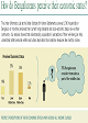
Wordlab2017-11-03 14:37:502020-01-31 21:35:26How do Bengalureans Perceive their Economic Status?
https://iihs.co.in/knowledge-gateway/wp-content/uploads/2017/11/How-do-Bengalureans-Perceive-their-Economic-Status.png
112
80
Wordlab
https://iihs.co.in/knowledge-gateway/wp-content/uploads/2018/01/iihs_logo_R_1-1.png
Wordlab2017-11-03 14:37:502020-01-31 21:35:26How do Bengalureans Perceive their Economic Status?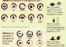 https://iihs.co.in/knowledge-gateway/wp-content/uploads/2017/09/Infographic.jpg
1559
1086
Wordlab
https://iihs.co.in/knowledge-gateway/wp-content/uploads/2018/01/iihs_logo_R_1-1.png
Wordlab2017-09-01 16:58:252021-10-04 10:46:27How Does the City Eat?
https://iihs.co.in/knowledge-gateway/wp-content/uploads/2017/09/Infographic.jpg
1559
1086
Wordlab
https://iihs.co.in/knowledge-gateway/wp-content/uploads/2018/01/iihs_logo_R_1-1.png
Wordlab2017-09-01 16:58:252021-10-04 10:46:27How Does the City Eat?